Difference between revisions of "Governor Thomas Johnson Bridge"
m |
(→Problems: Added photo.) |
||
| Line 27: | Line 27: | ||
The Thomas Johnson Bridge itself can be categorized as both a beam bridge and an arch bridge. Massive concrete pilings hold the bridge up over the river. | The Thomas Johnson Bridge itself can be categorized as both a beam bridge and an arch bridge. Massive concrete pilings hold the bridge up over the river. | ||
| + | [[Image:Thomas-Johnson-bridge-2.jpg|right|thumbnail|These braces were installed in 1988 to prevent the piers from failing. The highest piers have significantly more braces than shown here.]] | ||
==Problems== | ==Problems== | ||
| + | |||
In the summer of 1988, cracks were found in the foundation of the Thomas Johnson Bridge, causing it to be closed for repairs over several months.<ref>{{cite web | In the summer of 1988, cracks were found in the foundation of the Thomas Johnson Bridge, causing it to be closed for repairs over several months.<ref>{{cite web | ||
|url=http://www.highbeam.com/doc/1P2-1263729.html | |url=http://www.highbeam.com/doc/1P2-1263729.html | ||
| Line 44: | Line 46: | ||
People wishing to travel north into [[Calvert County]] were forced to make a half-hour detour to the [[Benedict Bridge]]. People wishing to travel south into [[St. Mary's County, Maryland|St. Mary's County]] were likewise forced to either utilize the [[Benedict Bridge]] or take a free charter boat across the [[Patuxent River]] to a park and ride lot on the southern side. | People wishing to travel north into [[Calvert County]] were forced to make a half-hour detour to the [[Benedict Bridge]]. People wishing to travel south into [[St. Mary's County, Maryland|St. Mary's County]] were likewise forced to either utilize the [[Benedict Bridge]] or take a free charter boat across the [[Patuxent River]] to a park and ride lot on the southern side. | ||
| − | + | As of September 2007, there has been much talk and public debate over either expanding the Thomas Johnson Bridge by adding a parallel span, or replacing the bridge with a four-lane bridge all together. The reasons for such proposals are two-fold. First, the recent increase in the amount of traffic of commuters traveling to and from the [[Naval Air Station Patuxent River|Patuxent River Naval Air Station]] in [[Lexington Park, Maryland|Lexington Park]] has made the the two-lane, single span bridge outdated for all intents and purposes. Traffic on the bridge during rush hour can cause back-ups all the way back to the [[Maryland Route 235|Route 235]] intersection, and instances where there is an accident on the bridge itself can cause total gridlock. | |
Secondly, the fear of more structural issues of the Thomas Johnson Bridge arising (such as the one in 1988), coupled with the apparent over-capacity use of the bridge on a daily basis, has caused some safety concerns about the bridge's stability.<ref>{{cite web | Secondly, the fear of more structural issues of the Thomas Johnson Bridge arising (such as the one in 1988), coupled with the apparent over-capacity use of the bridge on a daily basis, has caused some safety concerns about the bridge's stability.<ref>{{cite web | ||
| Line 59: | Line 61: | ||
|publisher=Baltimore Sun | |publisher=Baltimore Sun | ||
}}</ref> | }}</ref> | ||
| − | These fears have grown substantially in the wake of the | + | These fears have grown substantially in the wake of the I-35W Mississippi River Bridge collapse in Minneapolis on August 1, 2007. |
| − | + | ||
| + | As of September 2007, a study to determine whether the bridge should be expanded or replaced is being debated by Maryland governmental officials. | ||
==References== | ==References== | ||
Revision as of 21:20, 7 December 2008
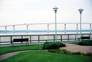
The Governor Thomas Johnson Bridge (also referred to as the Thomas Johnson Bridge and the Solomons Bridge) is a one and a half mile long bridge in Maryland over the lower Patuxent River joining Calvert and St. Mary’s counties. The bridge, named for the first governor of Maryland, Thomas Johnson, was built in 1977, and officially opened in January 1978.[1][2]
The bridge is one of two crossings of the Patuxent River in Southern Maryland. (The other is the Benedict Bridge approximately 20 miles up river, where Maryland Route 231 connects Calvert County and Charles County.)
Maryland Route 4 is the highway which crosses the Patuxent River at the Thomas Johnson Bridge. The north end of the bridge, on the Calvert side, is located in Solomons. Just prior to the bridge, Route 2-4 narrows from four lanes to two, and Route 2 exits off under the bridge and heads toward downtown Solomons. Route 4 continues onto the bridge itself and over the Patuxent River.
<googlemap version="0.9" lat="38.324824" lon="-76.466131" zoom="14" scale="yes" overview="yes"> </googlemap>
Description
The bridge itself only has two lanes but rises to a height of approximately 135 tall, making a trip over the bridge in windy weather somewhat nerve-wreaking for wary travelers. On the other hand, the view from the top of the bridge is quite impressive, as one can see the entire town of Solomons, the runways at the Patuxent River Naval Air Station, and the Chesapeake Bay. After reaching its apex, the bridge heads down to St. Mary's County. However, the bridge does not end once it reaches the banks of the Patuxent River, but rather continues for approximately a quarter of a mile over the tributary of Town Creek until finally reaching land on the south side. Route 4 remains a two-lane road from that point on, intersecting with Maryland Route 235 approximately three miles south, and then continuing on to Leonardtown for ten more miles.
The Thomas Johnson Bridge itself can be categorized as both a beam bridge and an arch bridge. Massive concrete pilings hold the bridge up over the river.
Problems
In the summer of 1988, cracks were found in the foundation of the Thomas Johnson Bridge, causing it to be closed for repairs over several months.[3][4] People wishing to travel north into Calvert County were forced to make a half-hour detour to the Benedict Bridge. People wishing to travel south into St. Mary's County were likewise forced to either utilize the Benedict Bridge or take a free charter boat across the Patuxent River to a park and ride lot on the southern side.
As of September 2007, there has been much talk and public debate over either expanding the Thomas Johnson Bridge by adding a parallel span, or replacing the bridge with a four-lane bridge all together. The reasons for such proposals are two-fold. First, the recent increase in the amount of traffic of commuters traveling to and from the Patuxent River Naval Air Station in Lexington Park has made the the two-lane, single span bridge outdated for all intents and purposes. Traffic on the bridge during rush hour can cause back-ups all the way back to the Route 235 intersection, and instances where there is an accident on the bridge itself can cause total gridlock.
Secondly, the fear of more structural issues of the Thomas Johnson Bridge arising (such as the one in 1988), coupled with the apparent over-capacity use of the bridge on a daily basis, has caused some safety concerns about the bridge's stability.[5][6] These fears have grown substantially in the wake of the I-35W Mississippi River Bridge collapse in Minneapolis on August 1, 2007.
As of September 2007, a study to determine whether the bridge should be expanded or replaced is being debated by Maryland governmental officials.
References
- ↑ Nora C. McArdle (February 15, 2005). "Maryland General Assembly — 2005 Session — Senate Bill 292". Department of Legislative Services.
- ↑ "Development of Our Roadways". St. Mary's County, MD.
- ↑ Eugene L. Meyer (June 21, 1988). "Johnson Bridge Closing Cuts Calvert, St. Mary's `Lifeline'". The Washington Post.
- ↑ John Lancaster; Robert Barnes (June 23, 1988). "Md. Bridge Structure Seen As Inadequate". The Washington Post.
- ↑ Michael Dresser (August 2, 2007). "Maryland bridges sound, officials say". Baltimore Sun.
- ↑ Michael Dresser (August 3, 2007). "Bay Bridge, 8 others to be reinspected out of 'abundance of caution'". Baltimore Sun.
External links
- Greg's Solomons Island, Maryland pictures from cityscapes photos on webshots Aerial view of the bridge
- VirtualTourist.com More pictures
- Pride II Log - November 1, 1999 Describes bridge and surroundings

